Informatics
Harris’ stratigraphic method /
STRATUM database /
CAD /
3D Laserscanning /
photo and video
Computer Support in Archaeology
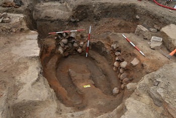
Today’s archaeology, just as most disciplines, doesn’t do without any use of computing devices more. Rescue excavations bring every year tens of thousands of finds and photos, thousands of pages of field documentation and hundreds of minutes of video records. Such a big “package” of information cannot be comfortably processed and archived now in any other way than with the help of a computer. From the origin in 1997 already, the Brno department of the company Archaia (later Archaia Brno) is concerned with a long-time development of methods of archaeological field excavations and their processing. An inevitable part of this methodical development is also represented by following of modern trends in the field of informatics and geodesy, and application thereof in archaeology and documentation of historical monuments.
Informatics within the company ARCHAIA Brno
Computer use in archaeology during the whole first half of the 1990s confined itself above all to texts written in the Czech software T602, and to simple card register K602 from one and the same producer. The dynamic development of computer technologies and software initiated particularly by the onset of Windows 95 in 1995 found soon reflection as well in the Brno archaeology. In this period began also a massive use of the package Microsoft Office, mainly of the text editor Word. In following year started a complicated development of a specialized database intended for field research in the environment of Access 2.0 named several years later – STRATUM. Gradually also the use of a foreign software for creation of stratigraphic matrixes had been pursued, at first they used WINBASP created by the colleagues from Bonn in Germany, then ArchED developed today under the heading of the Vienna University. Since 1998 also the field plans have been digitalized with the help of CAD – Microstation 95. Digital photograph came entirely to the front in 2004 only, with the onset of entry-level DSLR with the resolution over 6 mpx. All 35 mm film rolls (negatives and slides) from 1997 up to now are scanned and archived in the photo quality of 10 x 15 cm. In 2001 started the documentation of all excavations by a digicam. Elaboration of finding reports and various electronic outputs is also related to adjusting photos and video recordings in the programs Corel Draw and Adobe Premiere.
3D Laserscan
Another milestone in the field of documentation and measuring was overcome in 2003 as the 3D Laserscan was tested for the first time at an archaeological excavation in the Czech Republic, within the scope of a rescue archaeological excavation in the Panská St. in Brno. The application of this device in terrain we take for the biggest revolution in documenting historical monuments and archaeological finds within past decades.
Electronic presentations
Using the program PowerPoint to create scientific as well as popular presentations is for the workers of our company a matter of course some years already.
Data archiving
All the data gained through our excavations, namely photographs, plans, texts and databases are archived in an electronic form on the server at the headquarters of the company Archaia Brno. All data are backed up on DVD.
Patrimonium pro futuro
12. 06. 2025 – – zobrazit
Přátelé, sledující,
moc bychom si vážili toho, kdybyste nás podpořili v
hlasování „Patrimonium pro futuro“, které je každoročně vyhlašováno
Národním památkovým ústavem...


