About Excavations
The focal point of our research activity are rescue archaeological excavations, the main sense of which is to save information and finds being endangered by irretrievable devastation caused by destructive field encroachments. A rescue or as well advance archaeological excavation always consists of a
field part and of processing of its results into a finding report, which runs either concurrently to the field part or immediately thereafter. Opening of the field works is usually preceded by a preparation stage of the project.
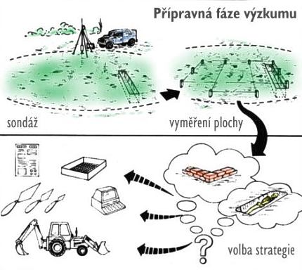
| 1) Preparation
stage of excavations serves
mainly for a preliminary determination of the extent and character of
archaeological situations on the endangered area. On the basis thereof
then a concrete sequence of rescue works is stated, and supposed
financial costs. The ground of the preparation stage consists in
collecting any accessible information on the endangered site, i. e.
searching for historical data in archive sources, their editions and in
professional literature as well as for the results of older
archaeological excavations or building-historical research.
Additionally also the results of geological survey can be used to
determine the thickness of anthropogenic layers. However, such kind of
information on a site is always just informative, it can be precised
only through a monitoring excavation (trial trenching). After the study
of building project documentation the extent of site endangerment is
determined and the information gained then creates a basis for dealing
with builders. |
 |
| 2)
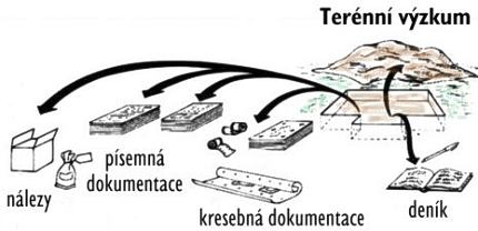
The most challenging stage is the proper field research.
In fact it is a professional unloading of archaeological landscape
under continuous documentation so that the archaeological sources in
given area vanish irretrievably. It is to be remembered that all the
finds are state property and handling with them is treated by relevant
legal standards. The excavation methodics emerges from the British
contextual (stratigraphic) method, i. e. a successive uncovering of
macroscopically recordable, continuously numbered stratigraphic units
(cuttings, layers, walls etc., i. e. remnants of human or natural
activities), of which then emerges the “Harris
matrix” – a diagram of mutual stratigraphic
relations of particular stratigraphic units. With the number of a
particular stratigraphic unit then the taken off finds and natural
samples are designated. Basic method is usually in details adapted to
the conditions of given research site. From any excavation they take a
drawing documentation fixed by planimetry and hypsometry, written
documentation and photo documentation, at especially significant
situations also a video recording. Documentation procedures underlie
the internal standards of the company. |
 |
| 3)
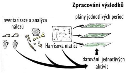
Basic processing of results
of field research is represented through the laboratory treatment of
finds and samples as well as through evaluation of the whole
documentation made. The laboratory processing consists in cleaning and
conservation of finds, registration of finds and samples or as well in
professional analyses thereof. It is often performed still before the
field works are finished to avoid any depreciation of finds and samples
in time. Processing of terrain documentation into the form of a finding
report usually runs after the field part of excavation was finished.
The drawing and measuring documentation is digitalized in computer with
the help of a tablet and further adjusted, the written documentation is
transferred into a special database application enabling further
evaluation, in a digital form also the photo and video documentation is
registered and archived. The entire information processed in such way
is arranged into a finding report containing also the evaluation of
so-called site stratigraphy (i. e. chronological relations of recorded
remnants of human activity), inventory list of finds and a text part
containing the interpretation of all the archaeological situations
uncovered as well as the information gained through the archive study
during the preparation stage already. A very important result is the
overall plans of particular time periods (prehistory, 13th century
etc.). |
 |
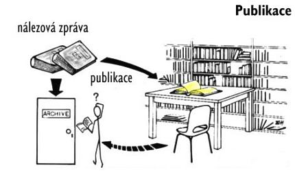
| 4)
The
finds recovered in the course of an excavation are state property and
after a laboratory treatment and elaboration of a finding report they
are usually deposited in particular regional museums where they can be
also further studied. A part of finds is then evaluated and published
by the company workers themselves by means of grant projects. All
finding reports are deposited in the archive of our company, and in
that one of the Institute of Archaeology of the Academy of Sciences of
the Czech Republic in Brno. |
 |
The illustrations used come from the publication of Martin Carver: “Underneath English towns, Interpreting Urban Archaeology, London 1987, 131.” The pictures are provided with Czech text
Stopami minulosti Kamenného Mlýna v Brně (Aneb silnicí I/42 Brno, VMO Žabovřeská I)
20. 11. 2024 – Lenka Sedláčková – zobrazit
V pondělí, 18. listopadu 2024, byl slavnostně otevřen další úsek
Velkého městského okruhu v Brně, konkrétně část Žabovřeská.
Pro mnohé je toto místo známé už jen jako důležitá dopravní
tepna, ale jen málokdo si dnes vzpomene na někdejší osadu Kamenný
Mlýn...


